


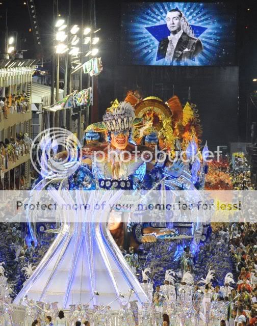
Brazil in full Cidade de São Sebastião do Rio de Janeiro, byname Rio Located on one of the largest harbours in the world and known for its scenic views, it was the capital of Brazil from 1822 to 1960, when the national capital was moved to Brasilia. It is the country’s second largest manufacturing centre, after Sao Paulo. City and port, capital of the estado (state) of Rio de Janeiro, Brazil. It is located on the Atlantic Ocean, in the southeastern part of the tropical zone of South America, and is widely recognized as one of the world’s most beautiful and interesting urban centres. Although Rio de Janeiro continues to be the preeminent icon of Brazil in the eyes of many in the world, in reality its location, architecture, inhabitants, and lifestyle make it highly unique when compared with other Brazilian cities, especially the country’s capital of Brasília or the much larger city of São Paulo.What is Carnival?Samba Scholl FloatGet to know the significance of Carnival as well as how the dates are really calculated. If you are like everybody else, you have probably asked yourself - before taking part of Rio Carnival or any other Carnival festivals in Brazil - what's the significance of Carnival? Carnival backgrounds come from Christianity. Carnaval marked the last opportunity to celebrate and make use of special foods before Lent, a six-week period where no parties or other celebrations were accepted, with people refraining from eating rich foods, recalling the biblical account of the forty days that Jesus spent in the wilderness. Lent serves to mark an annual time of turning to God and religious discipline. Carnival was then exported to Brazil by the Portuguese, who organized masquerade balls, held by members of the elite, while processions with decorated carriages in allegorical themes took over the streets, in the mid nineteenth century. That was the begining of the today famous Samba Parade at the Sambodromo.The Rio Samba Carnival ParadeIt`s helpful to understand that parade in Portuguese is desfile. It's a serious contest among different neighborhoods, divided into three leagues that vie for top ranking following the annual carnival parades. Preparations for the big Rio Samba Parade start in the year preceding Carnaval, with each samba school counts with thousands of supporters to make it happen. Months before the parade, a theme is chosen at every samba school. Then, after a fierce competition, the song is picked. Last, the costumes and floats are secretly created by locals inside their communities.Take a look to my slideshow with 100 pictures from Rio Carnaval 2010..The rehearsals take place by beginning of December - three months before the big samba parade - with carnavalescos - the school "architect" - choreographing the dances and the movements. By the same time, samba songs are released, recorded and sent to record stores for the entire population to get familiarized with. The Special Group is formed by twelve samba schools, with six schools parading in each of the two first nights - Sunday March 06 and Monday March 07. These two parades have a very similar setting and importance.
A drawing conducted by the organizers determines which schools parade when. The winner and 5 runners-up from the Special Group make part of the Winners' Parade the Saturday after Carnival, March 12 this year. The Access Group is composed by 12 samba schools, which all of them parading on Saturday March 05. The winner and the runner up are promoted to parade with the Special Group at the following year. The two less qualified also descend to Group B, which parades on Thursday March 04.
The sambadromeDiscover why the Rio Sambadrome is the biggest stage on earth. It's very easy. The Sambodromo - or Sambadrome - in Rio is the biggest stage on earth because it nightly hosts a parade with over 30,000 people showing off on a half a mile runway, to the delight of 90,000 spectators. Designed by Oscar Neimeyer and built in 1984, the Rio de Janeiro Sambadrome is a massive concrete stadium-like structure built along both sides of Avenida Marques de Sapucai, designed to create a runway for the schools to parade down until they reach the Apotheosis Square at the end where they manifest the magnificent magic of Carnaval, and dare the awestruck onlookers to deem any show on earth worthy of comparison. There are 12 samba schools from the 'special group' to perform. The first night, Sunday , 6 of these schools perform at the Sambadrome - Samba Parade Ground . Each of them has from 70 to 85 minutes to perform, and the parade finishes at the 'Praça da Apoteose' (the M shaped structure at the end of the avenue ). Each school has a different theme. Each samba school has an average of 4.000 participants.An experience that will be remembered for ever! Let's have a look more to the history of Rio!Rio de Janeiro became the colonial capital in 1763 and was the capital of independent Brazil from 1822 until 1960, when the national capital was moved to the new city of Brasília; the territory constituting the former Federal District was converted into Guanabara state, which formed an enclave in Rio de Janeiro state. In March 1975 the two states were fused as the state of Rio de Janeiro. The city of Rio de Janeiro became one of the 14 municipalities of the Metropolitan Region of Rio de Janeiro, or Greater Rio, and was designated the capital of the reorganized state. Despite loss of the status, funding, and employment it had enjoyed as Brazil’s capital, Rio de Janeiro not only survived but thrived as a commercial and financial centre, as well as a tourist magnet. Area city, 485 square miles (1,255 square km); Greater Rio, 2,079 square miles (5,384 square km). Pop. (2007 est.) city, 6,093,500; (2007 est.) Greater Rio, 11,563,302.Character of the cityAnnual pre-Lenten Carnival parade, Rio de Janeiro, Brazil. Rio de Janeiro is well known for the beauty of its beaches and of its peaks, ridges, and hills—all partly covered by tropical forests. The city is a centre of leisure for Brazilian and foreign tourists, and people wearing bathing suits can be seen walking in the streets and along the beaches or traveling on the city’s buses. Perhaps at no time is the city’s festive reputation better displayed than during the annual pre-Lenten Carnival, which enlivens the city night and day with music, singing, parties, balls, and street parades of brilliantly costumed dancers performing to samba rhythms. Rio is also an important economic centre, however, with activities ranging from industry and national and international trade to administration, banking, education, culture, and research.The city’s economic and social prominence grew in the 18th century after it became the main trade centre for the gold- and diamond-mining areas of nearby Minas Gerais. Later its status as a national capital and as the royal residence of the Portuguese monarch influenced Rio’s continued growth and helped it acquire a cosmopolitan atmosphere and a national character, free of regional conflict. After the city was relegated to being a state capital in the mid-20th century, however, a new regional consciousness began to develop. While São Paulo became entrenched as Brazil’s economic heartland and Brasília strengthened its position as the political hub, residents of Rio increasingly prided themselves on being the country’s cultural centre and Brazil’s most salient symbol to the rest of the world.The republican period When Rio de Janeiro, which had formerly been the capital of the empire, became capital of the republic of Brazil in 1889, it was already a considerable community. At the time of the 1890 census, it had more than 520,000 inhabitants on 61 square miles (158 square km), ranking it as the largest city in Brazil and one of the larger cities in the world.The 1891 constitution designated it the Federal District. During the federal administration of Pres. Francisco de Paula Rodrigues Alves, from 1902 to 1906, Rio de Janeiro was further transformed. A team of administrators and technicians drained swamps, cleared slums, paved and widened streets, and markedly improved health conditions, notably by reducing cases of yellow fever and smallpox. The central avenue (called Avenida Rio Branco from 1912), still the most important of the Centre, was opened during that period; Avenida Beira-Mar, running parallel to part of the south shore, was built on reclaimed land; and several other important avenues were opened. The population of the Federal District exceeded 1,000,000 by 1920 and increased to 1,750,000 by 1940. During that period the number of industrial establishments in the Federal District nearly trebled. Castle Hill was demolished, land reclamation increased the area in the Centre, and the first skyscrapers appeared. Streetcar lines, now moved by electrical power, multiplied. While settlement spread on the east coast, some areas to the north lost status—such as São Cristóvão, which became an industrial and lower-class residential neighbourhood. In the mid-20th century, metropolitan Rio de Janeiro grew beyond its formerly narrow confines because of immigration from other parts of Brazil, as well as a high rate of natural increase. The suburban population more than tripled to some 1.5 million between 1940 and 1960, at a time when the city proper exceeded 3.3 million.Following the transfer of the national capital to Brasília in 1960, Rio’s rate of population growth slowed somewhat, although the suburban population continued to mushroom. By 1980 there were more than 5 million residents in the city and 3.6 million in the suburbs. Although subsequent growth continued at a lesser rate, by the early 21st century the metropolitan population exceeded 11 million, of which nearly half resided in the suburbs. Beginning in the latter part of the 20th century, population growth, real estate speculation, and an amplified dependence on automobiles precipitated a series of changes in the city.
The highway system was expanded, with improved access to numerous suburban areas; still higher skyscrapers arose in the Centre; and larger residential towers increasingly replaced small apartment buildings and houses. Landowners, the industrial sector, and the financial sector favoured the changes; however, higher rents forced many poorer residents to move from the central city to the periphery or to the rapidly expanding favelas on the steeper hillsides. Meanwhile, many affluent families settled in the southwest, notably in Ipanema and Leblon and at sites farther down the coast. Rio has maintained its status as the second largest manufacturing centre in Brazil, after São Paulo. In addition, Rio’s service sector remains one of the strongest in the country, providing for increasing numbers of jobs in such areas as finance, communications, tourism and entertainment, public and private education, and computer engineering. Rio remains a major centre for cultural exhibitions and international conferences, and many of the more affluent and influential Brazilians keep homes there. Despite desperate conditions in the city’s favelas, as well as high rates of violent crime throughout the city, grave levels of air and water pollution, and myriad other problems, Rio de Janeiro is still widely recognized as one of the world’s more beautiful urban centres.The republican periodWhen Rio de Janeiro, which had formerly been the capital of the empire, became capital of the republic of Brazil in 1889, it was already a considerable community. At the time of the 1890 census, it had more than 520,000 inhabitants on 61 square miles (158 square km), ranking it as the largest city in Brazil and one of the larger cities in the world. The 1891 constitution designated it the Federal District. During the federal administration of Pres. Francisco de Paula Rodrigues Alves, from 1902 to 1906, Rio de Janeiro was further transformed. A team of administrators and technicians drained swamps, cleared slums, paved and widened streets, and markedly improved health conditions, notably by reducing cases of yellow fever and smallpox. The central avenue (called Avenida Rio Branco from 1912), still the most important of the Centre, was opened during that period; Avenida Beira-Mar, running parallel to part of the south shore, was built on reclaimed land; and several other important avenues were opened. The population of the Federal District exceeded 1,000,000 by 1920 and increased to 1,750,000 by 1940. During that period the number of industrial establishments in the Federal District nearly trebled. Castle Hill was demolished, land reclamation increased the area in the Centre, and the first skyscrapers appeared. Streetcar lines, now moved by electrical power, multiplied. While settlement spread on the east coast, some areas to the north lost status—such as São Cristóvão, which became an industrial and lower-class residential neighbourhood. In the mid-20th century, metropolitan Rio de Janeiro grew beyond its formerly narrow confines because of immigration from other parts of Brazil, as well as a high rate of natural increase. The suburban population more than tripled to some 1.5 million between 1940 and 1960, at a time when the city proper exceeded 3.3 million.Following the transfer of the national capital to Brasília in 1960, Rio’s rate of population growth slowed somewhat, although the suburban population continued to mushroom. By 1980 there were more than 5 million residents in the city and 3.6 million in the suburbs. Although subsequent growth continued at a lesser rate, by the early 21st century the metropolitan population exceeded 11 million, of which nearly half resided in the suburbs. Beginning in the latter part of the 20th century, population growth, real estate speculation, and an amplified dependence on automobiles precipitated a series of changes in the city.The highway system was expanded, with improved access to numerous suburban areas; still higher skyscrapers arose in the Centre; and larger residential towers increasingly replaced small apartment buildings and houses. Landowners, the industrial sector, and the financial sector favoured the changes; however, higher rents forced many poorer residents to move from the central city to the periphery or to the rapidly expanding favelas on the steeper hillsides. Meanwhile, many affluent families settled in the southwest, notably in Ipanema and Leblon and at sites farther down the coast. Rio has maintained its status as the second largest manufacturing centre in Brazil, after São Paulo.
In addition, Rio’s service sector remains one of the strongest in the country, providing for increasing numbers of jobs in such areas as finance, communications, tourism and entertainment, public and private education, and computer engineering. Rio remains a major centre for cultural exhibitions and international conferences, and many of the more affluent and influential Brazilians keep homes there. Despite desperate conditions in the city’s favelas, as well as high rates of violent crime throughout the city, grave levels of air and water pollution, and myriad other problems, Rio de Janeiro is still widely recognized as one of the world’s more beautiful urban centres. Sugar Loaf Mountain, a granite peak overlooking Rio de Janeiro and the entrance of Guanabara Bay, Rio de Janeiro lies on a strip of Brazil’s Atlantic coast, close to the Tropic of Capricorn, where the shoreline is oriented east-west; the city largely faces south. It was founded on an inlet of this stretch of the coast, Guanabara Bay (Baía de Guanabara), the entrance to which is marked by a point of land called Sugar Loaf (Pão de Açúcar), a “calling card” of the city. The Centre (Centro), the core of Rio, lies on the plains of the western shore of Guanabara Bay. The greater portion of the city—commonly referred to as the North Zone (Zona Norte)—extends to the northwest on plains composed of marine and continental sediments and on hills and several rocky mountains. The South Zone (Zona Sul) of the city, reaching the beaches fringing the open sea, is cut off from the Centre and from the North Zone by coastal mountains. These mountains and hills are offshoots of the Serra do Mar to the northwest, an ancient gneiss-granite mountain chain that forms the southern slopes of the Brazilian Highlands. The large West Zone (Zona Oeste), long cut off by the mountainous terrain, had been made accessible by new roads and tunnels by the end of the 20th century.ClimateAlthough the region’s climate is generally tropical, hot, and humid, the climate of Greater Rio is strongly affected by its topography, its proximity to the ocean, and the shape of the Southern Cone of South America. Along the coast, the breeze, blowing alternately onshore and offshore, modifies the temperature. Because of its geographic situation, the city is often reached—especially during autumn and winter—by cold fronts advancing from Antarctica, which cause frequent weather changes. But it is mostly in summer that strong showers may provoke catastrophic floods and landslides. The mountainous areas register greater rainfall since they constitute a barrier to the humid wind that comes from the Atlantic. The highest rainfall rate is found in the urban district of Jardim Botânico (more than 63 inches [1,600 mm]), where nearby coastal mountains trap humid winds from the Atlantic. The temperature varies according to elevation, distance from the coast, and type of vegetation. Winter (June–September) is particularly pleasant, both because of its mild temperatures and because it is, in general, less rainy than the summer (December–March), which is hotter as well. The annual average temperature at Rio is about 73 °F (23 °C).City layoutThe core of the city of Rio de Janeiro is the Centre, and the core of its large metropolitan area is the South Zone. The North Zone is a heavily populated industrial centre, while the now-accessible West Zone is the site of much of the city’s more recent growth.CentreRio de Janeiro Centre.The Centre corresponds approximately to the old city and is referred to as Cidade (Portuguese: “City” or “Downtown”). However, few colonial-era buildings or monuments remain, owing to a series of remodeling and modernizing efforts. Included in these changes were the demolition of old buildings and their replacement with larger and higher structures; the leveling of hills and the filling of lagoons, swamps, and stretches of the sea; the enlarging of streets and avenues for automobile traffic; and the construction of new infrastructure, such as the port, rebuilt in 1907. The Centre contains a number of buildings with styles that reflect these historical remodeling phases; hence, buildings from different eras and of various architectural styles are juxtaposed with one another.The Municipal Theatre, built at the beginning of the 20th century and still the main national theatre, is almost a replica of the Paris Opera House. The Ministry of Education building (1936), conceived by International-style innovator Le Corbusier and Brazilian architects, represents the Modernismo movement in Brazilian architecture of the 1930s, while the headquarters of the Bank of Brazil is an example of an International-style high-rise building. Two- or three-story houses, built at the turn of the 20th century and resembling those of some areas of Lisbon, compete for space with historical monuments, 8- to 12-story buildings constructed before the 1940s, 20- to 30-story buildings of the post-World War II era, and skyscrapers of more than 40 stories constructed since the 1970s. One of the most opportune areas of the Centre for observing this juxtaposition of architectural styles is Praça 15 de Novembro—or Praça Quinze, as it is also known—a historic plaza on the city’s colonial-era waterfront that was substantially renovated in 1997. It is bordered on the south by the well-preserved Carmo Convent and adjoining church (which once served as the palace of King John VI) and the modernistic black glass skyscraper towers of Cândido Mendes University that loom as its backdrop.
The Imperial Palace (Paco Imperial), a restored colonial-era structure, lies on the southeast edge of the plaza, while across the busy square is the 20th-century-era building that once housed the Rio de Janeiro Stock Exchange and now serves as a financial museum. Half a block to the southeast of the plaza lies the imposing Tiradentes Palace, home to the state legislature and an example of Neoclassical-style architecture, while just a few blocks farther southeast is the home of the Brazilian Academy of Letters, itself only three blocks from the mid-20th-century Modern Art Museum. Along the way from Praça 15 de Novembro to the sprawling museum are monumental government buildings of the 1930s mixed with much-newer courthouses, as well as Santos-Dumont Airport, which was built on landfill out into the bay. Northwest of the museum is Monroe Palace, the old senate building, which lies next to the wrought iron fences and lush foliage of the spacious Passeio Público park and gardens, an 18th-century recreation area that was thoroughly renovated in the early 21st century. A few blocks in the same direction, past the white arches of an 18th-century aqueduct, stands the modernistic cone of the Metropolitan Cathedral, with its spectacular 200-feet- (60-metre- ) high stained glass windows. Just to its north stand dramatically designed modern buildings, such as those that are home to Petrobrás and the National Economic and Social Development Bank. On a hill above them looms the Baroque São Antônio Convent, which overlooks the bustling interaction of vehicles and pedestrians in the Largo da Carioca. This lower area, filled with peddlers’ stalls and street vendors, is tucked behind tall skyscrapers lining the midstretch of busy Avenida Rio Branco, the spine of Rio’s Centre. Narrow streets dating from colonial times lead from this wide boulevard west to Praça Quinze. A few blocks south on Avenida Rio Branco is the National Museum of Fine Arts (Museu Nacional de Belas Artes), an example of French Neoclassical design. Across the street sits the Municipal Theatre, and a block down is its architectural sister, the National Library. The historic Municipal Legislature building, opposite the library, is on the edge of Cinelandia, a strip of sidewalk cafés, bars, restaurants, and cinemas extending down to the corner of the aforementioned Passeio Público.
Turning north instead of south from Largo da Carioca, several blocks of stores and dining establishments along narrow, virtually vehicle-free streets lead to the historic Our Lady of Candelaria Church and the massive bank buildings at the east end of the Avenida Getúlio Vargas, a wide, multiple-lane thoroughfare that runs west from the bay, beyond the limits of the Centre. Five blocks farther north, dramatically atop a hill, looms the imposing São Bento Monastery, site of one of Brazil’s outstanding parochial schools; just to its west lies Praça Mauá—a plaza that is home to businesses, government offices, and waterfront bars—and also the northern end of Avenida Rio Branco. A short distance west of Largo da Carioca lies Praça Tiradentes and the João Caetano Theatre. Three streets farther is the spacious Campo de Santana, a park that extends north to Avenida Getúlio Vargas, where its corner becomes the Praça da República. The historic War Ministry building, Dom Pedro II Station, and Itamaraty Palace—a restored colonial structure that was once home to Brazil’s foreign ministry and is now a museum—are nearby. A few blocks west of Campo de Santana is the long stretch of low-lying white buildings housing elementary schools for most of the year but briefly serving as the elongated stadium holding some 60,000 spectators for the Carnival competition among the largest escolas (in function, essentially community samba associations), each involving thousands of costumed dancers and musicians. At the north end of this stadium, popularly called sambódromo, is the monument to 17th century Afro-Brazilian hero Zumbi dos Palmares.South ZoneSouth of the Centre are a host of other scenic attractions. Over or around the picturesque hilltop district of Santa Teresa, with its narrow, winding streets still reached from the Centre by trolley, sits Laranjeiras Palace, the Rio residence of Brazil’s president, in beautiful Parque Guinle. Guanabara Palace, the residence of Rio de Janeiro state’s governor, is close by. Little more than a half mile to the east is Catete Palace. Once referred to as Brazil’s White House—where Brazil’s presidents worked when Rio was the capital of the country—it is now home to the Museum of the Republic. To its immediate north is the Largo da Glória, dramatically overlooked by Our Lady of Glória Church and flanked by São Joaquim Palace and a steep road leading up into Santa Teresa. Road leading to the summit of Mount Corcovado, Rio de Janeiro, Braz. Below these sights and a bit to the east is Flamengo beach, bordered by a beautifully landscaped extension of the parklike landfill that stretches back to the Centre. Flamengo, as the district is called, ends with the rocky protuberance of Widow’s Hill (Morro da Viuva), which marks the west side of breathtaking Botafogo Bay, whose eastern shore is dominated by Urca Hill and the even more spectacular Sugar Loaf Mountain (1,296 feet [395 metres] high). Inland to the west in the Cosme Velho neighbourhood lies the beginning of the funicular railroad to Mount Corcovado (2,310 feet [704 metres]) and the massive statue of Christ the Redeemer that crowns it. (The summit is also accessible via a road up Corcovado’s back side.) Rio’s mountains hem in the district of Botafogo, the shape of which resembles a reclining figure. Its head is on the beach, one arm stretches back toward Laranjeiras, and the other is draped along the bay to Red Beach (Praia Vermelha), the home of the National War College and the Army Staff and Command School, at the foot of Urca and Sugar Loaf. Botafogo’s body extends inland past such tourist sights as the Casa de Ruí Barbosa; the Indian, Theatre, and Villa-Lobos museums; the City Palace; and the few remaining former ambassadorial residences along Rua São Clemente. One leg is doubled up against Corcovado, while the other stretches toward the scenic Rodrigo de Freitas Lagoon with its toes pointing toward the National Fine Arts Museum in Lage Park. To the north of the lagoon—popularly called Lagoa—lies the Jardim Botânico district, which takes its name from Rio’s justifiably famous Botanical Garden. The Ipanema district of Rio de Janeiro, Braz., with its famous beach in the foreground.
The west edge of this large tidal-filled lagoon leads past Rio’s imposing Jockey Club to the upper-middle-class district of Gávea, home to Pontifical Catholic University. Curving south and then east, the shore marks the back side of the posh residential districts of Leblon and Ipanema to the south, with their exceptional beaches and opulent oceanside apartments and luxury hotels. Ipanema becomes less affluent as it merges eastward past Arpoador Point to Fort Copacabana, the west end of the famed tourist district of that name. As it sweeps east, “Copa” develops an inland salient connecting it to Botafogo’s waist and a thin arm reaching through tunnels to Botafogo’s shoulder. Beyond the busy Avenida Princesa Isabel, the area’s short eastern continuance takes on the name Leme. Along beachfront Avenida Atlántica, tall modern apartment buildings coexist with tourist hotels and sidewalk bars and cafés.North ZoneAlthough the lower edge of the North Zone is close in proximity to the Centre and the South Zone, travel between the areas is accomplished only with difficulty and delay, because of the mountainous ridge that runs east-west. Starting at Cosme Velho and Laranjeiras and ending miles beyond Gávea and Leblon, most of this rocky backbone is incorporated in Tijuca National Park. The generally middle-class district of Tijuca in the North Zone has its commercial centre at the Praça Saéz Peña, from which the subway begins its long horseshoe-shaped trajectory east to and through the Centre, then back south and southwest via Botafogo to its western terminus. To the west and north of Tijuca are the districts of Andaraí, Vila Isabel, and Maracanã, the latter home to Rio’s famed stadium of the same name. In the east, Tijuca runs toward the Centre through the districts of Rio Comprido, Catumbí, and Estácio. Tijuca then climbs southeastward to the heart of Tijuca National Park, the Alto da Boa Vista, where there are several waterfalls and spectacular vantage points that provide extraordinary views of the city sprawled out far below: by day a colourful tapestry of topography and roofs, at night thousands of lights that gleam like diamonds on a black velvet cloth. North of Maracanã, in the historical district of São Cristóvão, is the Quinta da Boa Vista, a park that is home to the National Museum and Rio’s renowned zoo. The former, originally the imperial palace, overlooks the Museum of the First Empire. North of this is the road leading to the long crossbay bridge to Niterói. Avenida Brasil continues north past these features toward the city’s immense industrial suburbs, passing a causeway that provides access to both the small island housing the Federal University of Rio de Janeiro and Governador Island, site of Galeão-Antonio Carlos Jobim International Airport. Along the route are the city’s only large flatland slums, the favelas, constructed on low-lying marshes. Many more people dwell in the remote districts of Rio’s North Zone. Railways and streetcar lines heavily influenced the development of the North’s original settlement, which progressed in tentacular form. During the mid-20th century, as bus service became the main form of urban mass transportation, the areas between the “tentacles” were settled. Commercial and service activities were established around the squares where traffic was concentrated. Tijuca and Meier emerged as important local centres; more-distant neighbourhoods later followed suit. Farther north, the more populous districts of Madureira, Mangueira, Ramos, and Padre Miguel have acquired an increasing proportion of the city’s light industry, mixed in with housing and service businesses.West ZoneDuring the 1970s and ’80s, Rio expanded rapidly to the west, along the coast. Following Avenida Niemayer from the end of Leblon and the Dois Irmãos tunnel out from Gávea, an upwardly mobile younger generation of professionals found suburban-style luxury in the neighbourhoods of São Conrado and Barra da Tijuca. An international autodrome, a convention centre, and ultramodern enclosed shopping malls served as magnets for a burgeoning number of gated high-rise apartment communities with their own schools, clubs, and boutiques. With the opening in the late 1990s of the Yellow Line Highway—running west from Governador Island, with tunnels piercing the mountainous barrier—the large inland area beyond Tijuca was opened up. As the population expanded beyond Jacarepaguá, new arrivals to the West Zone flowed farther northwest, toward Santa Cruz and Campo Grande. Many more established residence farther out along the coast, first reaching Guaratiba, then pushing toward the port at Sepetiba. Hence, Rio and its suburbs came to extend even farther west than they already had north.SuburbsThe suburban zone inside the municipality of Rio de Janeiro extends 12 miles (20 km) north from the Centre; still more suburbs are found in neighbouring municipalities. Indeed, these areas have experienced the most rapid growth of the metropolitan region since the 1950s, owing more to migrations from the interior of the state and other states than to natural increase. Most residents of the suburbs are poor, but each suburb contains areas of relative prosperity and modern facilities. Single-family houses dominate, although the number of apartment buildings has grown rapidly. Government housing programs of the 1960s attempted to relocate inhabitants of the favelas of the Centre and North Zone to the suburbs, but the population resisted being moved from areas that were in close proximity to their places of work. Programs since then have concentrated on rebuilding the favelas proper. Still, such programs have done little to stem the growth of the North Zone suburbs. Among the major suburbs of Greater Rio, each with a population of several hundred thousand, Nova Iguaçu and São João de Meriti lie to the northwest along the route to São Paulo; Belford Roxo and Duque de Caxias (also home to a major oil refinery) are situated to the north. Along with smaller cities such as Nilópolis, these suburbs are known collectively as the Baixada (Portuguese: “Lowland”) and were once small rural centres that grew tremendously after being linked by rail to Rio proper. Farther to the north of Rio de Janeiro city atop the escarpment is the satellite of Petrópolis, once the summer residence of the Brazilian royal family and former capital of Rio de Janeiro state (1894–1903). Located in the highlands at an elevation of 2,667 feet (813 metres), it is a summer tourist resort as well as a centre of light industry. Many weekend and vacation homes have been built between Petropólis and Rio’s industrial suburbs.
On the east shore of Guanabara Bay lies the major urban agglomeration, with a population of more than one million, that includes Niterói, a former capital of the state of Rio de Janeiro, and the much larger São Gonçalo. Commuting to and from Rio de Janeiro is via the Rio-Niterói Bridge and by ferries, motorboats, and hydrofoils. Motorboat service also links Rio to the resort island of Paquetá, which lies near the middle of the bay. Industries in Niterói-São Gonçalo include shipyards and textile, food-processing, and metallurgy plants. Magé stands at the head of the bay, separate from both the northern and crossbay suburbs.PeopleTwo faces of Rio de Janeiro. Rio’s inhabitants (called Cariocas, after the Tupi Indian word meaning “white man’s home”) represent a microcosm of Brazil’s ethnic diversity and include people of European, African, and mixed ancestry. In Brazil, people of African descent (referred to as “Afro-Brazilians” by outside scholars) can be further characterized using such terms as pardos and pretos; the latter term is used to refer to those with the darkest skin colour. Although skin colour is largely the basis of the distinction between pardo and preto, it is a distinction that is subjective as well as objective, and it is self-attributed. Many Brazilians of colour consider it more advantageous to identify themselves as pardos and therefore do so. About one-third of Rio’s pardos are clearly mulattoes (mulatos; people of mixed African and European ancestry), while the vast majority of the city’s small preto population do not claim any known European ancestry. Cariocas are primarily Roman Catholic, although many simultaneously observe the practices of the Umbanda religion (see Macumba). People of European ancestry live predominantly in the affluent neighbourhoods of Flamengo, Copacabana, Ipanema-Leblon, Jardim Botânico, and Gávea in the South Zone; in Tijuca in the North Zone; and stretching from Barra da Tijuca past Recreio dos Bandeirantes in the West Zone.
The northern suburbs, in contrast, contain much larger proportions of mulattoes, as do many districts of the North Zone. The heaviest concentrations of pardos and pretos are found in Rio’s favelas, regardless of location. The rich mosaic of areas of the North Zone are socially differentiated by the average level of income of their inhabitants, closely reflected in the urban infrastructure and public services that are locally available. While the ring of neighbourhoods closest to the Centre is deteriorated, the next ring contains more-prosperous areas. Farther out, however, poverty increases. Both distance from the Centre and elevation serve as determining factors for the location of favelas, since they have been established on all available steep hillsides as well as in undesirable swampy lowlands throughout the Greater Rio area. Historically, Rio’s population grew primarily as a result of domestic migration, which in some years accounted for two-thirds of the city’s increase, although many people immigrated from European countries as well.Government policies began restricting foreign immigration in the 1930s, causing the proportion of foreigners in the former Federal District to decline from 30 percent in 1890 to 7 percent in 1960. By that time, almost half of the city’s population were Brazilian migrants, most of them born in the states of Rio de Janeiro, Minas Gerais, and Espírito Santo. The largest groups of foreign-born immigrants in the Greater Rio area included those from Portugal, Italy, and Spain. The 1950s were Rio’s decade of greatest proportional growth, with the city expanding by nearly 40 percent and the suburbs almost doubling. However, with the transfer of the national capital to Brasília in 1960, the rhythm of population growth in the city declined. Most internal migrants were directed to other municipalities of the metropolitan region, leaving Rio to rely more on the birth rate within its own boundaries. Still, the city’s population grew steadily and did not begin to taper off until the 1990s, when Rio’s limited space—then near saturation—served to restrict further growth. With improved access to the West Zone beginning in the late 20th century, growth again began to pick up. At the beginning of the 21st century, more than four decades since Rio ceased to be the national capital, a large proportion of federal employees were still based there, along with tens of thousands of state and city workers. Moreover, retirees from public service jobs continued to constitute a significant element of Rio’s population. As the country’s cultural capital, Rio de Janeiro has many prestigious artistic, literary, and scientific institutions. These include the Brazilian Academy of Letters, the Brazilian Academy of Sciences, and numerous museums. Among the museums are the National Museum of Fine Arts, founded in 1818; the National Museum, rich in anthropological objects and located in the former Imperial Palace of the Quinta da Boa Vista; the National Historical Museum; the Museum of Modern Art; and the Indian Museum. The most important of the city’s many libraries is the National Library; it was founded in 1810 with the remaining volumes of the Royal Library of Ajuda, which were brought to Brazil from Portugal after the devastating earthquake of 1755 in Lisbon. Sizeable auditoriums and concert halls throughout the Greater Rio area are available for popular performing artists, but the chief venue for visiting international orchestras, dance troupes, and soloists is the Municipal Theatre, which also presents performances by local groups. Many of Brazil’s leading performing artists make Rio their base when not traveling overseas. Rio has a large number of movie theatres, many radio broadcasting stations, and several television stations including the home station and studios of TV Globo, the country’s principal network. Many periodicals are published there, and the variety of daily newspapers includes two of national range, the O Globo and Jornal do Brasil. A significant proportion of Brazil’s publishing houses are located in Rio. Statue of Christ the Redeemer (right) atop Mount Corcovado, overlooking central Rio de Janeiro, … Among the picturesque places frequently toured are Mount Corcovado and its famous statue of Christ the Redeemer; Sugar Loaf Mountain, which is reached by a funicular railway; the Quinta da Boa Vista, a park in which the Zoological Garden, as well as the National Museum, is located; the Botanical Garden, which dates from 1808 and displays a huge variety of species; and Tijuca National Park, located in Tijuca Forest. Carnival dancers, Rio de Janeiro, Braz.Rio’s world-renowned Carnival, the highlight of which is the samba schools parade, lasts for four days each year and attracts many tourists. It is a traditional festival in which the people of the city enthusiastically participate. Samba schools, which serve as community associations, are found throughout the city and are most active during the height of Carnival. Some schools are much more active year-round, including those of the northern districts of Madureira, Mangueira, Ramos, and Padre Miguel, where preparation for the next year’s Carnival begins not long after the current year’s celebration comes to an end. The principal samba schools also offer performances throughout the year, both in Rio’s large tourist-oriented nightclubs and at their own facilities. The most popular sport in Rio de Janeiro, as in Brazil as a whole, is football (soccer). Rio’s major league teams—Flamengo, Vasco da Gama, Botafogo, and Fluminense—are internationally known. Each team has its own stadium, but the most important matches take place in Rio’s renowned Maracanã Stadium, which has a large seating capacity. Volleyball, tennis, and basketball are other popular sports. For several million Cariocas, the city’s celebrated beaches are of even greater popularity and use. International auto races are held in the western suburb of Jacarepaguá. Rio was the host of the 2007 Pan American Sport Games, the Western Hemisphere’s quadrennial sporting event.The colonial period - HistorySeveral years after the Portuguese first explored Brazil, French traders in search of pau-brasil (a type of brazilwood) reached the rich area extending from the Cape Frio coast to the beaches and islands of Guanabara Bay—the economic and, above all, strategic importance of which was already well-known. On one of these islands, the French founded a colony that was called La France Antarctique (Antarctic France). The Portuguese wanted to expel the French from Brazil, and the task was given to Estácio de Sá, a nephew of Gov. Mem de Sá of Brazil, who in 1565 occupied the plain between Dog Face Hill (Morro Cara de Cão) and the Sugar Loaf and Urca mounts, thus laying the foundations of the future town of Rio de Janeiro. After two years (1565–67) of bloody battles, in which Estácio de Sá was killed and the French expelled, Mem de Sá chose a new site for the town, farther inland on the coast of the bay, at the top of the Hill of Rest (Morro do Descanso), or St. Januarius Hill (São Januário), later called the Castle Hill (Morro do Castelo). In 1568 the settlement was laid out in the form of a medieval citadel, protected by a bulwark and cannons.
The surrounding fertile land, allotted to Portuguese settlers by the Portuguese king in enormous plots called sesmarias, was planted with sugarcane, which was to provide the colony with its main source of income. In 1660 the community became the seat of the government of the southern captaincies (Portuguese administrative units) of Brazil. In the second half of the 17th century, the captaincy population grew to 8,000 inhabitants, two-thirds of whom were probably African slaves and Indians.At the beginning of the 18th century, Brazil began to engage in gold and diamond mining, which brought about remarkable changes in the colony’s economy and stimulated a great migration from Europe, thereby increasing the number of people of European ancestry. The former village became a town of 24,000 in 1749. When the colonial capital was transferred from Bahia to Rio de Janeiro in 1763, the town expanded farther, far beyond its walls. The remains of the monumental Roman-style aqueduct Arcos (“Arches”) built at this time still stand in the city. At the end of the 18th century, the town’s economy, as well as that of the colony as a whole, was in a crisis because of the decline of the mines and competition from Central America for the world sugar market. In 1796 the value of exports from Rio’s port was less than half of what it had been in 1760. Coffee production and the resettlement of the Portuguese royal family in Brazil in 1808 again brought prosperity to the colony.
By 1815, when Brazil became a kingdom, Rio de Janeiro was large enough to accommodate a foreign population. At about that time the city’s original appearance was being transformed; from 1808 to 1818 some 600 houses and 100 country houses were built, and many older buildings were restored. Many streets were lighted and paved, more land was reclaimed, new roads were opened, and new public fountains were installed. Among new institutions established were the Royal Press, the Royal Library, the Theatre of Saint John, the Academy of Fine Arts, the Botanical Garden, and the Bank of Brazil. When King John VI returned to Portugal in 1821, Rio had almost 113,000 inhabitants and 13,500 buildings, and the town had extended both northward and southward. A year later Brazil was independent.The city after independenceExpansion of coffee plantations in the state of Rio de Janeiro gave a new impulse to the city’s development. Nobles and bourgeois moved their residences north to the São Cristóvão district. Merchants and English bankers chose to live around the Outeiro da Glória and Praia do Flamengo areas in the south, or they established their residences in the nearby Botafogo and Laranjeiras districts. The French, on the other hand, lived in country houses scattered in the Tijuca area farther westward. In that era, as Brazil expanded its world export trade in such products as coffee, cotton, sugar, and rubber, the city changed its appearance, and the traces of its colonial past were effaced. In 1829 oxcart traffic was banned from the Rua do Ouvidor, then the city’s most elegant street. In 1838 the first public transportation—horse-drawn buses—began to run to the districts of São Cristóvão, Engenho Velho, and Botafogo. In 1868 the first tramcars, also drawn by animals, were introduced. A steamboat service to Niterói began to operate in 1835. The first railroad was built in 1852 to Petrópolis, and a line reached Queimados in the Nova Iguaçú area in 1858. In 1854 gas replaced oil for street lighting, and wireless telegraphy was inaugurated. Sewerage was installed in 1864, and telephone service began in 1877.The republican periodWhen Rio de Janeiro, which had formerly been the capital of the empire, became capital of the republic of Brazil in 1889, it was already a considerable community. At the time of the 1890 census, it had more than 520,000 inhabitants on 61 square miles (158 square km), ranking it as the largest city in Brazil and one of the larger cities in the world. The 1891 constitution designated it the Federal District. During the federal administration of Pres. Francisco de Paula Rodrigues Alves, from 1902 to 1906, Rio de Janeiro was further transformed. A team of administrators and technicians drained swamps, cleared slums, paved and widened streets, and markedly improved health conditions, notably by reducing cases of yellow fever and smallpox. The central avenue (called Avenida Rio Branco from 1912), still the most important of the Centre, was opened during that period; Avenida Beira-Mar, running parallel to part of the south shore, was built on reclaimed land; and several other important avenues were opened. The population of the Federal District exceeded 1,000,000 by 1920 and increased to 1,750,000 by 1940. During that period the number of industrial establishments in the Federal District nearly trebled.Castle Hill was demolished, land reclamation increased the area in the Centre, and the first skyscrapers appeared. Streetcar lines, now moved by electrical power, multiplied. While settlement spread on the east coast, some areas to the north lost status—such as São Cristóvão, which became an industrial and lower-class residential neighbourhood. In the mid-20th century, metropolitan Rio de Janeiro grew beyond its formerly narrow confines because of immigration from other parts of Brazil, as well as a high rate of natural increase. The suburban population more than tripled to some 1.5 million between 1940 and 1960, at a time when the city proper exceeded 3.3 million. Following the transfer of the national capital to Brasília in 1960, Rio’s rate of population growth slowed somewhat, although the suburban population continued to mushroom. By 1980 there were more than 5 million residents in the city and 3.6 million in the suburbs. Although subsequent growth continued at a lesser rate, by the early 21st century the metropolitan population exceeded 11 million, of which nearly half resided in the suburbs. Beginning in the latter part of the 20th century, population growth, real estate speculation, and an amplified dependence on automobiles precipitated a series of changes in the city. The highway system was expanded, with improved access to numerous suburban areas; still higher skyscrapers arose in the Centre; and larger residential towers increasingly replaced small apartment buildings and houses. Landowners, the industrial sector, and the financial sector favoured the changes; however, higher rents forced many poorer residents to move from the central city to the periphery or to the rapidly expanding favelas on the steeper hillsides.Meanwhile, many affluent families settled in the southwest, notably in Ipanema and Leblon and at sites farther down the coast. Rio has maintained its status as the second largest manufacturing centre in Brazil, after São Paulo. In addition, Rio’s service sector remains one of the strongest in the country, providing for increasing numbers of jobs in such areas as finance, communications, tourism and entertainment, public and private education, and computer engineering. Rio remains a major centre for cultural exhibitions and international conferences, and many of the more affluent and influential Brazilians keep homes there. Despite desperate conditions in the city’s favelas, as well as high rates of violent crime throughout the city, grave levels of air and water pollution, and myriad other problems, Rio de Janeiro is still widely recognized as one of the world’s more beautiful urban centres.
 You can listen all here - if you don't have patiance to read, just push the button!


Acum 2 luni


7 comments:
Hi Dyeve.
Very interesting post.:)
Have a great week.
Will.
Hello, Dyeve. Okay?
I loved his class about Rio de Janeiro! Much of what I read I didn't know .. Can I make some comments? For example, in the summer, we have temperatures of 42 º C on the boardwalk along the beach (some days). That the people of Rio de Janeiro is considered the most hospitable of Brazil, however, is also famous for being the most liberal people in Brazil (you just can see the daring eroticism in the carnival, which has lost its religious meaning for a long time). The suburbs - slums (favelas) - are mostly dominated by drug dealers, some of which were dominated by militia (out-law police) who demand protection of residents and are now one more problem for the state. But since recently a movement called PACIFIC POLICE are taking some slums and keeping them, definitely taking away traffickers and the militias. The problem is that there are many slums still to be taken, but we expect that good politicians continue taking these favelas, 1 by 1, if necessary, to turn this beautiful city more secure for everyone that visit or live there.
PS: Brasil is best known by Rio and Its carnival, but Brasil is bigger than this! You shoud know Brasil northeast, Amazonia, Pantanal matogrosense, Minas Gerais state, South of Brasil with the european influence, and the incredible coexistense between jews and palestinians in the same neighborhood in São Paulo and Rio also!
Thanks!!!
Hi Dyeve!
Wow that is a-lot of information. Very interesting. I have to agree with Anderson on his comment "daring eroticism in the carnival, which has lost its religious meaning for a long time"
Take care,
jay.me =)
@Will
Thank you . Have a great one week you too!
XO
@Anderson Wasser
Andy. you make my day! :)
I loved you're comments..
Plss,you're welcome
with any informations you have about Brasil.."meu amor secreto"..really.
Long time ago I watched the movie "Clone" from which I learned a lot about Brazil, I said. I sow Pele, favelas, many good or bad thinghs about Brasil, but not necessarily because of the movie, also I love the music and the dance from there, a lot..( I like to dance..:D) and I still dream that next year .. probably I will manage to go to Carnival in 2011
( hope God!). As you noticed the post is filled with pictures from the Carnival of 2010, that's showing that I'm crazy already about that..:)))
I'm sure that there are many beauties of this wonderful country, but I do not think I'll ever manage to visit all over as I want ... as many are unable to visit other countries I would love to walk. .
It would be necessarly at least 100 years for me to do this kind of thinghs ..:))
Thanks again for your beautiful comments, even made me much pleasure to hear the "keys" to someone who lives there .. describe as honest about this country
Thanks
Xo
@Jay me
Yesss..Anderson has his right..but even like that.I love the rhytm of samba..Pele, Ronaldo Luiz Nazario..and many others..Look to the last picture I posted it here, for me..this is a real brasilen one girl. :D
I just love them.. <3
Have a splendid night, Jay!.. and take care with the dragons..:P..They are beautiful but dangerous..:)
Thx again
XO
nice pics of Brazil, its either samba ON or OFF the field
Trimiteți un comentariu